There are lists of some slave uprisings in the late 1600s. There were gallows next to Beaver Pond.

Courtesy of Carl Ballenas
February 21, 2013

From the ancient glaciers to slavery, Carl Ballenas knows Queens. Born in Brooklyn, Ballenas moved to Queens as a toddler in 1965 and never left. “Everything in Queens fascinated me,” he says. A history teacher at the Immaculate Conception School in Jamaica Estates, he has written several books on local history, even involving his students in the research and fact-finding.
Through Arcadia Publishing’s “Images In America” series, Ballenas has published books on the adjacent Southeast Queens neighborhoods of Richmond Hill, Kew Gardens (and its famed cemetery, Maple Grove), Jamaica and Jamaica Estates. Although these places now look very different—Kew Gardens is mostly co-ops and high rises, while Jamaica Estates is home to large, Victorian mansions—they were originally part of one community, Jamaica. The process of how land was acquired from local Native American tribes and then parceled out to various developers is something Ballenas and his students in the Thomas Aquinas Honor Society explore in their books on Jamaica and Jamaica Estates.
I caught up with Ballenas after he visited York College this month for a lecture. I asked him about the Richmond Hill and Jamaica history that hides in plain view–in Queens’ topography, its architecture and the names we use everyday.
—
OC: What was the first historical project you researched?
CB: The first project was about the history of St. Benedict Joseph Church in Richmond Hill. I was told it was the only parish with that name. While researching, I kept coming across “Morris Park.” I was like why? This is Richmond Hill. I found out there were other towns—like Morris Park—that eventually got absorbed by Richmond Hill.
OC: Let’s start way back. What do geologists tell us about this area?
CB: The hills that make up the backbone of Long Island, north of Hillside Avenue–hence named–were created 10,000 years ago by a glacier, which moved huge boulders and large amounts of soil. When it eventually stopped, it deposited all those things. So from Hillside Avenue south to Jamaica Bay is level, because those things flattened everything out. In the 1870s, when people started settling in this area, the ocean breezes and cooling temperatures in the flat area were part of the area’s attraction.
OC: What is the most interesting architectural find in this area?
CB: We’ve found the Lefferts Farmhouse. The Lefferts family sold their farm to Mr. Albon Platt Man, the founder of Richmond Hill. The farmhouse may date all the way back to the 1830s, and it wasn’t in the same location–that was one of the most amazing things we found–people used to move houses!
And we also found the Captain Briggs farmhouse. Briggs was a veteran of the War of 1812, who retired to Richmond Hill to become a gentleman farmer. He won many awards for his pear orchards. You find these little remnants of the past poking out at you.
I also like correcting the mistakes that have been written about this place. Sometimes we would find references to “Richmond Hill lakes.” The truth is, when it rained there were temporary lakes caused by the lack of a sewer system, and some people believed there were really lakes!
OC: Was there slavery here?
CB: Oh yes. It wasn’t as abundant as in the south, where the weather meant there was planting all year around. In the north, it was difficult to grow crops and feed a large number of slaves during the winter. Northern slaves would take care of horses and do housekeeping.
In the town archives there are lists of some slave uprisings in the late 1600s. There were gallows next to Beaver Pond, in the town center, and there were some executions.
OC: How did Jamaica get its name?
CB: According to research, it came from the word “Jameco” from the Native American Canarsie tribe, who lived by the Jamaica Bay area. It means “Land of the Beaver.” The area was inhabited by beavers, and one pond that no longer exists anymore was called Beaver Pond.
OC: In your talk, you spoke about commemorating George Washington’s visit to Jamaica.
CB: There are so many avenues one can go down. The students were shocked to learn about the separation between the colored schools and the white schools in Jamaica in the early 1900s and the ongoing fight for desegregation. Another direction is that we came across a newspaper article on a hotel being torn down in 1906, and people were reminiscing, saying that George Washington had stayed there. It turns out that in 1791, on an official presidential tour of Long Island, George Washington had written about the hotel in his diary. He said it was decent hotel, and he liked it. We figured out that the hotel was at the site of the current Social Security building in Queens. The students and I would like to place a historical plaque there–it’s been two years since we proposed it.


OC: Were there any fossils dug up around here?
CB: I came across a newspaper article from 1880s about the discovery of the remains of a wooly mammoth during a dig near Baisley Pond in South Jamaica. They were working on the water system. I’d love to find out what happened to those remains.
OC: Let’s jump far forward. How many Native American or indigenous tribes were there in this area?
CB: On Long Island, there were 12 groups, and some of them have lent their names to contemporary towns: Massapequa, Canarsie, Montauk, Seatauket, Shinnecock, Rockaway and Manhasset are some. Jamaica Avenue is really part of an ancient Indian trail that extended all across Long Island down to Ohio.
OC: What is the procedure for getting young students involved in historical research?
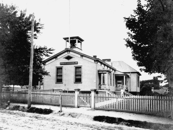
CB: It all started with a walk around our school to look at the cornerstones. Two of the dates on the stones were different, which puzzled them. We learned that the school was built in two stages. But how can you study the history of the parish without studying the history of the town?
So we went to the library and we looked at the maps. We found names, and looked up those names in the newspaper. I would highlight names, like the businessman and the architect, and assign students to go on the internet and find out what they did.
One of the men involved in a key 1907 Jamaica land deal was Micheal Degnon, who was in construction. He had a great quote: “You can be wrong 75% of the time in Manhattan real estate and still make money.” As we were researching this, the students realized we were standing on part of the 16 acres of land he had purchased.
OC: This area of Queens has changed tremendously. Do you think this generation will keep good records for the future?
CB: I’m not too worried. Every kid has a cell phone and is capable of keeping records. Cameras are everywhere. But what do you do with all this information? The kids have to have an appreciation for it. It’s not just a photograph—it’s also the caption. What good is a photograph without a caption? Family photographs with no remarks are a lost record.
OC: What are some of the unanswered questions that you are interested in?
CB: There are a couple things I’d like to work on. I would love to do a mock-trial based on the school war in Jamaica, Queens to end segregation in New York City. That led to Teddy Roosevelt signing a law ending segregation in New York State.
There was something else. I once found a sentence in a newspaper that was almost a gossip column. It’d read: “The grass in the colored cemetery on Rockaway Avenue was cut neatly.” But I’ve never seen or heard anything else about a colored cemetery in that area. Where is it? I’d like to find out.


